The Rongai route is the only route that approaches Kilimanjaro from the north, close to the Kenyan border. Though gaining popularity amongst climbers, Rongai has low traffic. It is the preferred route for those looking for an alternative to the crowded Marangu route, for those who would like a more remote hike, and for those who are climbing during the rainy season (the north side receives less precipitation).
| Duration | 7 Days 6 Night |
|---|---|
| Tour Type | Hiking |
| Group Size | No size Limit |
| Guides Languages | English |
| Package Includes |
Private Transportation to and from your selected Route Airport pick up Quality, Waterproof, four-season private mountain sleeping tent for camp route Certified, experienced, English speaking mountain guides All Kilimanjaro National Park Fees Government Climbing Taxes Climbing permits All hot Meals prepared by our cook while on Mountain Guides, Porters and Cook Salaries Fair and ethical treatment of Porters Enough porters to carry your luggage Personal Summit Certificate signed by the National Park and your Guide |
| Excluded |
Personal items and toiletries
Accommodation before & After trek Hotel (available as an optional addon) Transfers (available as an optional addon) Personal trekking equipment such as sleepings bags, hiking boots, clothes, etc (available for renting) Tips for guides, porters and cook International airfares and departure taxes All items of person nature such as telephone call, fax, email etc Alcoholic and non-alcoholic drinks Visa and International flight tickets fees. |
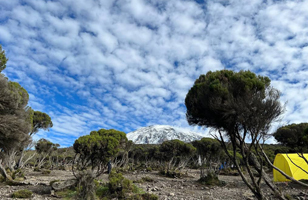
Drive to the attractive wooden village of Nale Moru (about 2 hours including a stop to get permits at Marangu). After signing in and preparing the porters, you will begin the hike on a wide path that winds through fields of maize and potatoes before entering pine forest. The track then starts to climb consistently but gently through attractive forest that shelters a variety of wildlife. The forest begins to thin out and the first camp is at the edge of the moorland zone with extensive views over the Kenyan plains.
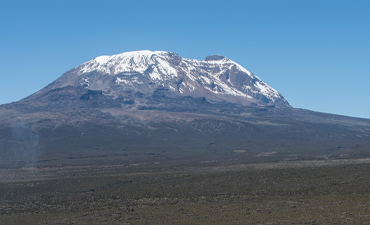
The morning hike is a steady ascent up to the Second Cave with superb views of Kibo and the Eastern ice fields on the crater rim.
Head out across the moorland on a smaller path towards the jagged peaks of Mawenzi. The campsite is in a sheltered valley with giant Senecios nearby. Elevation: 3450m/11,300ft to 3600m/11,800ft Distance: 9km/5mi Walking Time: 2-3 hours Habitat: Semi-desert Meals: Breakfast, Lunch and Dinner
A short but steep climb up grassy slopes is rewarded by superb views. Leave the vegetation behind shortly before reaching the next camp at Mawenzi Tarn, spectacularly situated in a cirque directly beneath the towering spires of Mawenzi. The afternoon will be free to rest or explore the surrounding area as an aid to acclimatization.
Cross the lunar desert of the ‘Saddle’ between Mawenzi and Kibo to reach Kibo campsite at the bottom of the Kibo crater wall. The remainder of the day is spent resting in preparation for the final ascent very early.
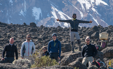
Very early in the morning (midnight to 2am), commence the climb to the summit on steep and heavy scree or snow up to Gilman’s Point located on the crater rim (elev 5700m/18,700ft). Continuing, we now ascend to Uhuru Peak, which is the highest point in Africa. There are unbelievable views at every turn. Have your picture taken at the summit to show your friends and family. From here we descend, stopping for lunch and a rest at Kibo before continuing on to the Horombo encampment. The beginning of this climb is done in the dark and requires headlamps or flashlights. It will be very cold until you start descending, so you will need all of your warm layers. This is by far the most difficult part of the trek with many switchbacks. Going slowly “pole pole” and an optimistic attitude will get you there!
After breakfast, a steady descent takes us down through moorland to the Mandara Hut. Continue descending through lush forest path to the National Park gate at Marangu. At lower elevations, it can be wet and muddy. Gaiters and trekking poles will help. Shorts and t-shirts will probably be plenty to wear (keep rain gear and warmer clothing handy).Drive back to the hotel.
| Solo = | $1,750 USD |
|---|---|
| Group of 2 = | $1,854 USD |
| Group of 3 = | $1,800 USD |
| Group of 4+ = | $1,750 USD |